Nature Notes: A Maine Naturalist Afield

Transcript
It’s winter in the Upper Saint John Wet Flats.
I’m up at first light, sipping coffee and watching the steady glow building over the looming hedge of black spruces and bare tamaracks opposite the window. A check of the thermometer shows its -2°F, but a glance at the frost-covered alders is all I need to know the day is off to a bitter start. My vantage over this winter scene is from within an old bunkhouse built and formerly owned by International Paper, now belonging to The Nature Conservancy along with the surrounding 185,000 acres of conserved woodland.
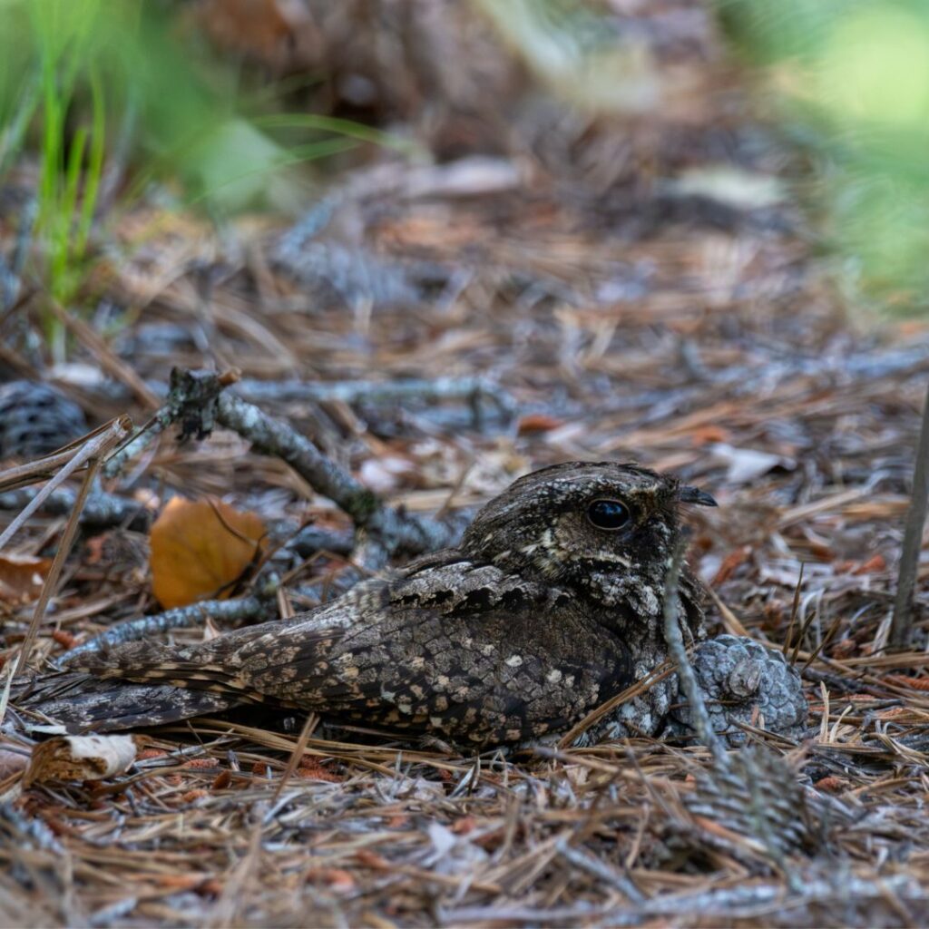
I’ve been coming to this remote field station intermittently for four years now. It served as a base of operations while I worked to cover this remote section of the state during the winter portion of the recently completed Maine Bird Atlas. More recently, working in collaboration with the Nature Conservancy, I was able to secure permission to install a Motus radio station here by retrofitting an old, 60-foot communications tower with antennas tuned to pick up signals from nighthawks I’d captured and outfitted with radio tags over the summer. The purpose of this most recent trip is to ensure the station remains in working condition and to gather whatever data has been compiled since my visit last September.
The Upper Saint John Wet Flats is a relatively small ecoregion within the state. Situated along the border with Quebec in Northwestern Maine this portion of the Northeastern Highlands is bisected by the Aroostook and Somerset county line. The first portion of its name is somewhat self-explanatory. Several tributaries of the Saint John River flow through the area, converging before flowing northeast into the Saint John Uplands. Another defining feature of the region, as its name suggests, is its wetness. Wetlands dominate much of the land area, including several expansive sphagnum-carpeted bogs and shallow tannic ponds. Although somewhat higher in elevation than much of the state, the topography of the area is relatively level with only a handful of small poplar-crowned hills rising above lowland swamps dominated by spruce, tamarack, cedar, and dense thicket of alder. Both of these characteristics are the result of “dead ice” – an arrested section of glacier that ceased its northern migration, compressing the area and depositing a dense moraine of its accumulated till. The water table remains near the ground surface and flooding is common.
The Wet Flats exude a strongly boreal character, particularly in those areas of conserved land along the river where the forest has been allowed to grow unimpeded. Further from the river, timber harvest continues. In these cutover areas, early successional plants have established footholds. The closure of a border crossing north of the Daaquam River and subsequent removal of a bridge over the St. John has rendered the north section of the area increasingly remote. The last 20 miles of my drive were over unplowed roads. Although there were no recent signs of other humans passing this way, the road had seen heavy traffic recently, evidenced by the numerous tracks of wildlife utilizing the roadway to traverse the landscape. This place could hardly be described as uninhabited. I spot the tracks of moose, deer, hare, squirrel, coyote, fox, and lynx. The going is slow enough that I even spot the tracks of mice in the vegetation along the roadside.
The varied landscapes of the Wet Flats support a diverse array of bird species as well, even in winter. Setting out at midmorning, I make my way to Burntland Brook, stopping to document whatever bird species I encounter along the way. Both Black-capped and Boreal Chickadees can be found here and bands of foraging Golden-crowned Kinglets are never far. Throughout my drive, I encountered a handful of boreal finch species including White-winged Crossbills, Evening Grosbeaks, and a flock of Pine Grosbeak. Some dark shapes high in a tall Quaking Aspen turn out to be a group of five Ruffed Grouse, all busy foraging on the tree’s leaf buds.
Towards the end of my trek, I crossed paths with quite possibly the most charismatic residents of the area – Canada Jays. Their high whistles and whines can be heard at a distance before they glide into view. Rather than dive into the surrounding forest for cover, these “whiskey jacks” often descend to surround trespassers and eye them with as much curiosity as is directed towards themselves. After a few moments inspection, seeing that I had no nuts or seeds to share, they made their noisy retreat into the tangle of bare limbs and dangling lichens.
It was nearing midday and the snow-covered roadway was awash with the glare of sunlight. Although the air temperature was only about 15°F, I could feel the faint suggestion of the sun’s warmth on my face. After soaking in my surroundings for a moment, I climbed back into the truck and started the slow and steady plod back to the bunkhouse.
Related Episodes
-

1/11/26: Maine’s Pine Barrens, part 3
In this episode, Logan shares nighttime experiences studying whip-poor-wills in Maine’s barrens, describing the shifting soundscape, dense scrub oak…
-
12/28/25: Maine’s Pine Barrens, part 1
In this episode, Logan introduces Maine’s rare pitch pine–scrub oak barrens, explaining how glacial sands, fire, and other disturbances…
-
12/8/24: Seasonal Shift
The transition from summer to autumn ushers in more than just magnificent foliage. Join Logan on a stroll through…